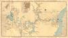
Congress created an Isthmian Canal Commission to direct the Panama Canal project. The commission issued this map of the canal route, which stretched approximately 50 miles through mountains and bodies of water. Drawn by John Stevens, one of three chief engineers during the canal’s 10-year construction, the map indicated locations of locks, dams, and the Panama railroad.
Geography and Map Division, Library of Congress
Map Showing Line of Proposed Lock Canal with Summit Elevation at 85 feet, map by the Isthmian Canal Commission, 1906
Creating the Panama Canal
Congress was central to creating the Panama Canal, one of the Progressive Era’s furthest-reaching strategic, trade, and technological achievements. In the 1890s Congress investigated potential routes for a canal linking the Atlantic and Pacific Oceans, deeming it essential for commerce and defense. After Congress authorized the purchase of a canal project initiated by France on the Isthmus of Panama, the Senate approved a treaty to acquire the Canal Zone in 1904. Appropriating $375 million for construction, Congress established a commission to oversee the project, which was completed in 1914.
Congress created an Isthmian Canal Commission to direct the Panama Canal project. The commission issued this map of the canal route, which stretched approximately 50 miles through mountains and bodies of water. Drawn by John Stevens, one of three chief engineers during the canal’s 10-year construction, the map indicated locations of locks, dams, and the Panama railroad.
Geography and Map Division, Library of Congress